Email 通知
預計寄信時間:2011/08/24 PM 23:59 (此通知已於預定時間寄送完畢)
寄件者: 本活動管理員
收件者: 山谷所有會員
通知訊息:
[快報] 距離活動開始還有 3 天! John Muir Trail --PCT 最美的一段 | |
|
 領隊: 領隊: | 天涯過客 | | 活動管理者: |  Happyhiker(Happy Hiker) Happyhiker(Happy Hiker) | | 時間: | 11/08/28(日) 至 11/09/14(三) 共 18 天 | | 開始地點: | 美加 | | 發表者: | 10/09/29 (三) 00:32:31 Happyhiker(Happy Hiker) 75.37.* | | 最後修改: | 12/12/09 (日) 06:42:15 Happyhiker(Happy Hiker) 75.37.* | | 人數限制: | 12 人 | | 有效報名人數: | 7 人 | | 報名者清單: | 報名已結束
| ‧ | 11/05/16 1 人 土豆 Happyhiker | | ‧ | 11/05/16 4 人 寶貝1, 寶貝2, 寶貝3, 寶貝4 yoyo | | ‧ | 10/10/22 1 人 Shiow-Yun Pan showpan 此報名已於 10/11/16 被設定為無效 | | ‧ | 10/10/22 1 人 Shiow-Yun Pan showpan 此報名已於 10/10/22 被設定為無效 | | ‧ | 10/10/21 1 人 鳥腳 Happyhiker | | ‧ | 10/10/04 1 人 Eric Lee EricLee 此報名已於 11/02/18 被設定為無效 | | ‧ | 10/09/29 1 人 Happy Hiker Happyhiker |
| | 經由地點: | | | 結束地點: | | | 活動分類: | 海外登山 | | 登山類型: | | | 活動難度: | 難度高,具有挑戰性,參加者需有豐富經驗 | | 行程說明: |
年輕時曾經妄想登上喜馬拉雅山, 現在可能連走完 Pacific Crest Trail 的夢,都只好放棄,但是,無論如何John Muir Trail 是不能再放棄了. 因為,沿途實在很美. 今年9月中和一個陌生人登上 Mt. Lyell, 優勝美地最高峰 (陌生人是臨時認識的, 朋友都認為我太離譜, 可是我需要的只是有人知道我在哪裡出事, 路線我都研究好了,帳篷食物也都自己揹, 還有甚麼需要的呢...) 那時走在 Lyell Canyon Trail (John Muir Trail 的一小段), 一路陶醉在寬廣的河谷, 在自然的美景中, 我的心一直是處在"空靈"的狀態, 就這樣埋下走John Muir Trail的心願. 回來後, 加上李昆明學長的鼓勵, 於是, 飛馬公主又再度重現山谷 (洛磯山旅之後就已決定退隱山谷, 不想再辦活動了, 只想把時間留給自己和山林獨處)
對於我來說, 爬山的動機是 "追求美的境界", 不是"征服", 更不是 "自我挑戰". [相關連結] http:\\picasaweb.google.com
This is the best hike in the USA and includes many of the best sections of the longer Pacific Crest Trail.
The John Muir Trail (JMT) stretches 212 miles(340 km) between Yosemite National Park in the north and Sequoia National Park in the south, terminating/beginning on the summit of Mount Whitney. Passing through what is arguably some of the finest alpine territory in the world, the trail works its way through 3 National Parks (Yosemite, Kings Canyon and Sequoia), two designated wilderness areas (John Muir Ansel Adams Wilderness), and a national monument (Devil's Postpile). Passing alongside 14,000 foot peaks and countless lakes and streams, the trail offers endless views, fishing, mountain climbing, and something for the adventurer in us all.
Route:
The official length of the JMT, as stated by the United States Geological Survey (USGS), is 211 miles (340 km). From its northern terminus in Yosemite Valley, the trail runs northeast, passing south of Half Dome and then on to Tuolumne Meadows. From Tuolumne Meadows the trail turns south, running parallel to the main range of the Sierra Nevada, through Yosemite National Park, Inyo and Sierra national forests (including the John Muir and Ansel Adams wilderness areas), passing through Devils Postpile National Monument, through Kings Canyon National Park, and ending on Mount Whitney in Sequoia National Park.
From the southern terminus of the John Muir Trail at the summit of Mount Whitney, an additional 11-mile (18 km) hike on the Mount Whitney Trail is required to reach the nearest trailhead at Whitney Portal, thus making an end-to-end traverse of the trail effectively 220 miles (350 km).
Elevation:
With the exception of the first 9 miles (14 km) at the northern end climbing out of Yosemite Valley, the elevation of the John Muir Trail seldom dips below 8,000 feet (2,400 m). The trail crosses six passes in excess of 11,000 feet (3,400 m); from north to south, they are: Donohue Pass, Muir Pass, Mather Pass, Pinchot Pass, Glen Pass, and Forester Pass (the highest, at 13,153 feet (4,009 m)).
When the length of the John Muir Trail was calculated by the USGS, elevation gain and loss was not taken into consideration. It is estimated[who?] that, when hiking north to south, the amount of ascent of the JMT is just over 46,000 feet (14,000 m) and the total descent is just over 38,000 feet (12,000 m), for a total of about 84,000 feet (26,000 m), or almost 16 miles (26 km); however, this does not mean the total length is increased by 16 miles (26 km).
"Wilderness Permit" :
First, you must apply up to 24wks to the day in advance of your intended start date. Try to get them online as there is a daily quota at all trailheads. Forest Service Permits. Sequoia-Kings Canyon National Park Service Permits. Yosemite National Park Permits.
Wilderness Center, Yosemite Village
PO Box 545, Yosemite, CA, USA, 95389,(209) 372-0740
[相關連結] http:\\www.besthike.com
[相關連結] http:\\www.backpack45.com
| | 飲食(水)注意事項: | | | 裝備注意事項: | | | 住宿注意事項: | | | 交通注意事項: | | | 費用(台幣): | 均攤 | | 領隊電話: | 650 892-1511 | | 嚮導: | Happy Hiker | | 留守人: | | | 留守人電話: | | | 備註事項: |
(1) 1/31/2011 以前繳訂金 US$50, group permit 很難拿到, 必須六個月前預定.
請用PayPal 付款 [相關連結] https:\\www.paypal.com ,
付給 電子郵件
請選 personal 付款理由 other, 否則會有手續費的
(2) 不需要走完全程 340Km, 可以中途加入或下山,
(3) 食物會以郵寄的方式寄到中途的登山口
Yosemite south, drop at Reds Meadows' Resort, one 4 days later at Vermillion Resort,
Vermillion Resort is one of the highlights of the trip with meals, and sleeping facilities for hikers, and a small store. They make a special effort to welcome both PCTers and JMTers - first beer and first night are free. Great pie. ATT cell service works at VVR. They also have internet via satellite.
Muir Trail Ranch is a couple of days south of Vermillion Resort and does hiker resupply. MTR welcomes hikers, but just does resupply. Its lodging & meals are for guests. They are located at the east end of Florence Lake. A ferry shuttle service goes across the lake every two hours in summer.
(6) 必須能每日重裝爬升 1500 ft -2000 ft, 10-15 miles
| | 行前會議時間: | | | 集合時間地點: |
Yosemite National Park
| | 是否需報名: | 需報名 | | 報名電話: | 650 892-1511 | | 報名期限: | 2011/08/31 23:59:59 |
| | | 活動相關討論: | | |
|
| 發表   lctseng2(Fifty) lctseng2(Fifty) | | 寫入 11/02/14 (一) 19:02:08 From 220.228.* | Dear HappyHiker,
請問你何時回台灣? 不知你有無時間一起吃飯, 跟你認識, 以及請教這個行程? 謝謝
桹人
| | ↑ |
|
| | | 發表 Happyhiker(Happy Hiker) | | 寫入 10/12/09 (四) 12:19:41 From 75.37.* | 哈囉桹人
我選擇從北往南走的理由是,Yosemite 後山的 permit 比較好拿.
選擇從南到北時, permit 是在 Mt. Whitney, 然而 Mt. Whitney 是用抽籤的,
我的經驗是很難, 因為 Mt. Whitney 是美國本土最高峰,
你問我哪一段值得,
前段很美,比較簡單
後段很俊,不簡單
只要有補給站, 基本上都是你可以加入的點
比如
Day 5 Devils Postpile
Day 8 Vermillion Resort
Day 10 Muir Trail Ranch
Day 13 Deer Meadow
Devils Postpile 基本上就在公路旁, 所以很容易跟我們會合
關於補給,打算用寄的方式,把食物和燃料寄到指定的地方, 有人會送去定點,
詳情請參考 (你若能打開 我的google doc, 就可以看到下面的link)
[相關連結] http:\\www.edisonlake.com
[相關連結] http:\\www.muirtrailranch.com
[相關連結] http:\\www.redsmeadow.com
你若是中途加入, 就可以將補給帶給我們了.
歡迎加入
HAPPY HIKER
| | ↑ |
|
| | | 發表 lctseng2(Fifty) | | 寫入 10/12/08 (三) 13:36:20 From 220.228.* | Dear HappyHiker,
今年Rocky mountain原想說台灣這邊沒人要過去, 怕跟大家不熟, 所以就沒有參加, 非常遺憾, 因為爬山人安排的行程還是最符合我的preference
很高興又看到爬山行程, 但想先了解一下, 如果假期只有10天或2週, 你會建議走哪幾段? 另, 順便問一下中途補給要如何安排
謝謝
桹人
| | ↑ |
|
| | | 發表 Happyhiker(Happy Hiker) | | 寫入 10/10/21 (四) 04:36:43 From 75.37.* | John Muir Trail 的里程 和 高度
 | John Muir Trail 的里程 和 高度
(91 KB) |
| | ↑ |
|
| | | | 發表 Happyhiker(Happy Hiker) | | 寫入 10/10/21 (四) 03:33:26 From 75.37.* | 這是我 目前暫定的行程, 大家可以提出建議
[相關連結] https:\\spreadsheets.google.com
John Muir Trail 大致可以分為 4 段, 個人可以由中途加入 或 下山
第一段:從Yosemite 的Tuolumne Meadow Ranger Station 出發
第二段:From Shadow Lake to Florence Lake Trail, total 58.9 miles
第三段:From Florence Lake Trail to Woods Creek Crossing, total 58.9 miles
第四段:From Woods Creek Crossing to Mt. Whitney, total 44.2 miles
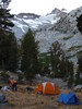 | 第一天的營地, 遠山就是 Yosemite 最高峰 Mt. Lyell(887 KB) |
| | ↑ |
|
|
※ 相關說明:
-
只要是山谷會員皆可使用線上報名功能。
-
線上報名成功不代表您能參加此活動,最終由領隊決定報名是否有效。
-
報名者可以將報名「設定為無效」 (但仍會留下報名記錄)。
-
若要「刪除報名」不留下報名記錄則必須請該活動管理者「刪除報名」。
-
活動「發表人」為當然之活動管理者。
-
活動管理者有「設定活動管理者」、「編修內容」、「刪除報名」權限。
例:
活動「發表人」阿貴指定阿霞成為「活動管理者」,接著阿霞也可指定阿娟為「活動管理者」,如此阿貴、阿霞、阿娟皆為活動管理者,都有「設定活動管理者」、「編修內容」、「刪除報名」權限。
|
|